|
|
This edition of ENews is sponsored by two of our newest Chamber Members. We thank them for joining the Chamber. |
|

|

|
Good Morning Chamber Members and Community: It's the last full weekend of February. The ice and snow from last month's storm is finally melting away. Walking and traveling is returning to normal. Today, February 21, is a good day to get outside and visit family and friends, and shop, dine, and enjoy yourself right here in the Bridgeton area. It's also what is referred to as the "calm before the storm."
Yes, the National Weather Service has issued a winter storm warning for our area, affecting all of NJ and nearby states. Though forecasts have varied, most are now in agreement that snow is coming starting Sunday afternoon and evening. The intensity of the storm varies in terms of snowfall amounts with a low of 6 to 10 inches projected by one forecaster to as much as 10 to 20 inches by another.
What's important is to be prepared for the storm and to remain safe.
Here is the National Weather Service Winter Storm Warning for the Bridgeton Area. WINTER STORM WARNING IN EFFECT FROM 10 AM SUNDAY TO 6 PM EST MONDAY... WHAT...Heavy snow expected. Total snow accumulations between 10 and 18 inches. Winds gusting as high as 40 mph. WHERE...Camden, Cumberland, Gloucester, Northwestern Burlington, and Salem Counties. WHEN...From 10 AM Sunday to 6 PM EST Monday. IMPACTS...Travel could be very difficult to impossible. Areas of blowing snow could significantly reduce visibility. The hazardous conditions could impact the Monday morning and evening commutes. Gusty winds could bring down tree branches. ADDITIONAL DETAILS...Snowfall rates could exceed 2 inches per hour. Locally higher snowfall amounts possible. Blowing and drifting of snow, and whiteout conditions possible. PRECAUTIONARY/PREPAREDNESS ACTIONS... If you must travel, keep an extra flashlight, food, and water in your vehicle in case of an emergency. The latest road conditions for the state you are calling from can be obtained by calling 5 1 1. |
|
|
|
|

|
As we prepare for a cold, snowy winter weekend, one of our new Chamber Members, Bridgeton Rotary Club, tells us about 2 fundraising events they have planned, one this weekend that you can participate in without leaving the comfort of your home, and one on March 28 where you can dance the night away with classic rock and roll by The Jack Neff Band. This weekend, now til 5 PM on Feb. 24, you can order Double Good Popcorn and 50% of sales go the Bridgeton Rotary Club. The orders will be delivered right to your home or business in 7-10 days. You can use this link to go to a Club Member's Pop-up Store to make a purchase. https://s.dgpopup.com/m24aj7q9
|
|
|
Invest New Jersey Article Focuses on Cumberland County's Growing International Food Connection |
|

|

|
|
Check out upcoming Chamber, Member, and Community Events |
|

|
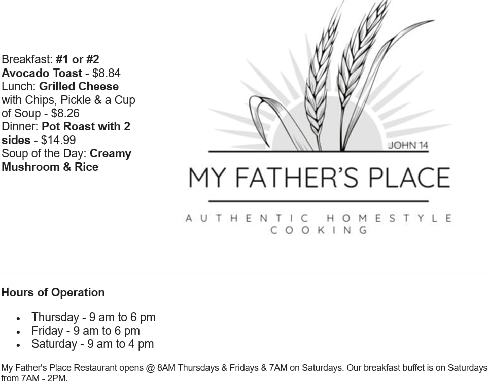
SATURDAY, FEB. 21, IS A GOOD DAY TO VISIT, SHOP AND GET WEEKEND SPECIALS. |
|

|
|

|

|
Visit us on Social Media! |
|
|
Bridgeton Area Chamber of Commerce PO Box 1063, Bridgeton, NJ 08302 856-455-1312 * bacc@baccnj.com * www.baccnj.com Jon Cummings, President Tony Stanzione, Chief Executive Officer Laurie LaTorre, Member Services Coordinator
See why Cumberland County is the best location on the East Coast for your business. See full video. See 1 min. video. |
|

|

|
|
|

|
|

|
Premier Partnerships are available now. |
|
Click here or contact us to discuss and sign-up. |